Pine Trees Farm housing development – County Highways respond to consultation
The County Council is a consultee for the planned housing development on the edge of Northrepps (“West of Pine Tree Farm”). Here is their letter to North Norfolk District Council, the council that decides on the planning application:
Having reviewed the application, we offer the following comments:
Vehicular Access onto Norwich Road
Two points of vehicular access are proposed, and the applicant has put forward a left in / left out option for the northern access. The applicant suggests the reason for this is a lack of forward visibility for southbound vehicles approaching over the rail bridge, which could potentially lead to southbound vehicles having limited view of stationary right turn vehicles. Which in turn could lead to accidents such as rear end shunts. It is the view of the highway authority that for a development of this size both accesses should be open to all movements and not be limited (such as left in / left out). Further options should be considered for the design of the northern access, including the potential for a signal-controlled junction.
Should the application be approved a full detailed design review of the proposed roundabout would be required to discharge relevant conditions. However, to determine the acceptability of its principle further information should be included within the drawing to demonstrate necessary design criteria such a visibility splays can be secured within the extent of the applicant’s land control and do not adversely affect the existing properties to the north.
It is proposed the 30mph local speed restriction will be extended along Norwich Road, covering the new roundabout. How will the environment / character of Norwich Road north of the roundabout be enhanced to help re-enforce the extended limit?
Transport Assessment / Modelling
Further information is required to support the TA. In addition to the junctions already referenced in the TA, the following junctions should also be assessed:
- A149/A148 (Louden Road, West Street, Prince of Wales Road) junction
- A140 Norwich Road mini roundabouts with Chapel Road B1436 and Thorpe Market Road B1436 (both in Roughton)
- B1436 roundabout with A148
For all junctions being assessed (those above and those already referenced in the TA) easy to read summary tables should be included within the body text of the TA comparing the modelling results for all 4 scenarios: Base year, 2030, 2030 + committed development and 2030 + committed development + proposed site.
Distribution should be based on 2011 census data.
Why are there no capacity values in some of the modelling outputs?
The proposed development is likely to increase use of Carr Lane, potentially as a short cut to the B1436 which offers a route to the A148. Carr Lane is limited in width with a lack of passing provision. The junction of Old Mill Road with the B1436 has been considered previously in response to application PO/18/1551, at which time concerns were raised regarding increased vehicle movements at this junction that suffers a lack of forward visibility. What measures are proposed to deter increased use of Carr Lane?
Active Travel
Most of the site straddles the catchments for primary schools in Roughton and Northrepps. Given the distances involved and the lack of available land, it is unrealistic to expect a safe walking route between the site and each of these schools.
The closest schooling, employments, retail opportunities and other key local services are located to the north in Cromer.
The applicant is proposing/promoting Burnt Hills / Roughton Road as the active travel route linking the site with Cromer. However, given the location of schooling and other local services within Cromer, the main pedestrian and cycle desire-line generated by the proposed development would be northeast of the site via Norwich Road. A lack of proposed provision for walking, wheeling & cycling facilities along Norwich Road is unlikely to supress demand and would result in walking and wheeling (in particular) unprotected within the carriageway and onwards via the existing substandard footway at the railway bridge. Furthermore, visitors to the proposed sports facility may be unaware of the proposed access arrangements and arrive at the development’s northeast access, unaware that no off-carriageway walking/cycling route is available.
If this site is to be developed, it is essential that high quality walking, wheeling and cycling facilities are provided along Norwich Road, linking the site with key services and providing safe access to/from the proposed sports facilities.
As an alternative to a bridge over the railway the applicant is proposing a toucan crossing south of the proposed northern access. The existing footway east of Norwich Road, including the footway across the bridge, is limited in width to around 1m. The existing footway is wholly inadequate to accommodate the likely increase in walking, wheeling and cycling activity. Rather than encourage active travel, the substandard nature of the existing facilities is likely to have the opposite effect. The proposed toucan is not a suitable alternative and a dedicated bridge should be provided across the railway.
Residents of the proposed development should be able to exit either of the proposed junctions on Norwich Road to access public transport connections on the A149. It is unrealistic to expect all residents accessing public transport to head south within the site and access public transport from the roundabout. Neither is it realistic to expect people to leave via the northern junction, walk south passed the southbound bus stop, cross at the roundabout, and then head north back the way they came to catch the bus. The desire line for people accessing the southbound bus would be to cross Norwich Road north of/in the vicinity of the stop. The proposed development does not provide adequate facilities to allow people to safely access public transport on Norwich Road and is likely to result in pedestrians crossing the A149 Norwich Road (which is a busy and important traffic route with strategic functions) where there is no recognised crossing, to the detriment of highway safety.
Given the likely increase in active travel demand to / from Roughton Road (e.g. to/from public transport and rail facilities etc) improvements will be required in the form of footway widening and cycleway connections.
The concept masterplan proposes open space beside/linking to Roughton Road south of No249. While there may be no formal path or pedestrian route shown through the open space offering pedestrians access to Roughton Road, the mere fact open space would exist at this location will inevitably encourage people to access between Roughton Road and the development at this location. To accommodate these movements and provide people with safe walking facilities along Roughton Road footway should be provided linking the site with the existing footway to the north.
Consideration needs to be given to:
- Active travel connections north along Norwich Road connecting the site to schooling and key local services.
- Active travel connections to Roughton Road and to local public transport & rail connections. Notwithstanding the content of the Walking & Cycling Route Strategy, improvements to existing facilities would be required to accommodate the increased demand.
- A149 Norwich Road is a key public transport corridor. How will residents access these services safely?
Where possible, cycle provision should be designed in accordance with LTN1/20.
Public Transport
The proposed development is likely to increase demand for existing services operating on both Norwich Road and Roughton Road. It is essential that appropriate footway is in place for residents to safely access the services on both roads. As well as ensuring there are high quality walking routes both north and south along Norwich Road, both stops should be enhanced to provide:
- Laybys so buses do not hold up traffic on the A149.
- Shelters
- Realtime information
- Crossing facilities across A149
Given the likely increase in demand for services along Norwich Road, a financial contribution of £350,000 toward the operation of an half-hourly service should be provided to cover a period of 3years. This contribution would be secured via S106.
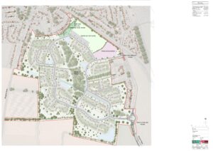
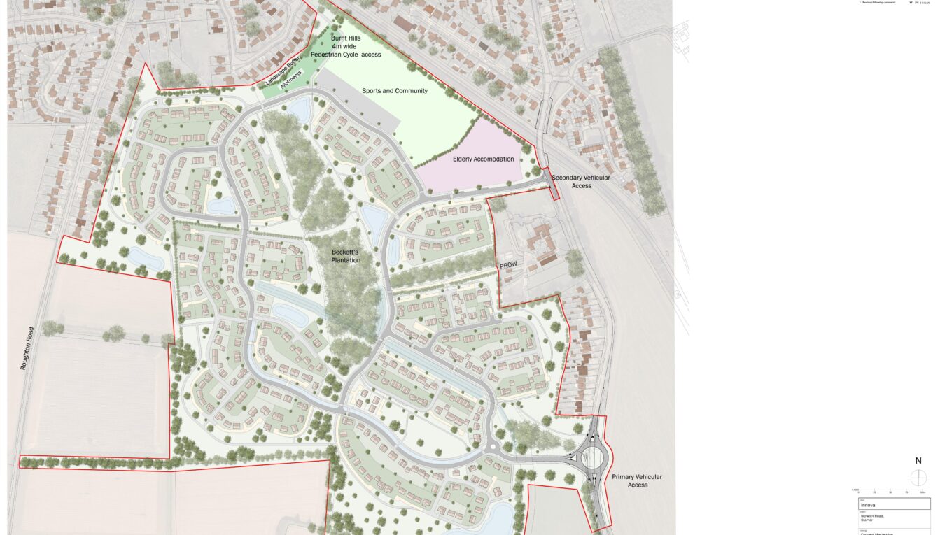
Layout – Concept Masterplan (23-052338-0100-J)
It is recognised at this stage layout is not marked for consideration. The following is offered for information:
- New estates in Norfolk are subject to 20mph zones. Rather than rely in vertical traffic calming features, the layout of the estate roads should be designed to contain vehicle speeds.
- Primary roads through the site should be 6.5m wide. Bends in these roads should have at least 30m centreline radii. Junctions onto these roads should have 10m radii.
- Shared surface roads should serve a maximum of 25 dwellings.
- Unless otherwise agreed all internal junctions should be provided with visibility splays of 2.4m x 33m. Where necessary footways / cycleways / verges should be widened to cover the width of splays.
- Cycle provision will be required through the site. This should be designed as segregated facilities in line with LTN1/20.
- Policy C22/2 requires the existing PROW through the site (Northrepps FP16) to be retained and enhanced.
- The site extent borders Roughton Road at 2 locations. This has potential to lead to pedestrian access to/from Roughton Road. How will this be accommodated?
- Visitor parking should be incorporated into the site at a ratio of 1 space per 5 dwellings.
- All cul-del-sacs (estate roads or private roads) should have appropriate turning provision. Any cul-de-sac 45m+ in length should have turning provision suitable for a refuse/delivery vehicle.
- Basins / lagoons should be designed to ensure likely maintenance vehicles have adequate access.
- Early consideration should be given to how estate roads will be drained. If features such a filter drains and swales are proposed, sufficient space must be retained to fit these into the street scene.
- Pedestrian and cycle routes (whether adoptable or private) should benefit from natural surveillance and not direct users to narrow secluded locations that may result in personal safety concerns.
- All proposed uses (residential, allotments, sports and community and elderly accommodation) should have parking provision in accordance with current guidance.
- Shared private drives should be provided with communal bin collection points to prevent bins being left within roads / footways / cycleways on collection day.
- Any future detailed proposals should be supported by tracking plans demonstrating large refuse vehicles can manoeuvre around all estate roads.
Summary
The highway authority has long stated that if this site is to be developed it is essential for high quality active travel connections to be provided along Norwich Road linking the site to local schooling, services and public transport, including a route over the railway bridge. It is the view of the highway authority the application as submitted does not provide this.
Additional information is required to support the form of the second point of access (which could potentially be signals), wider network impacts, active travel and public transport.
As the proposal currently stands the highway authority recommends refusal for the following reasons:
SHCR 02
The proposed development does not adequately provide off-site facilities for pedestrians / cyclists / people with disabilities (those confined to a wheelchair or others with mobility difficulties) to link with existing provision, local public transport provision and / or local services.
SHCR 31
The application is not supported by sufficient highways and / or transport information to demonstrate that the proposed development will not be prejudicial to the satisfactory functioning of the highway / highway safety.
As mentioned above it is recognised the site is included within your authority’s emerging local plan, reference C22/4. The highway authority would be willing to review the proposals further on receipt of amended plans / additional information.